ShopDreamUp AI ArtDreamUp
Deviation Actions


Suggested Deviants


Suggested Collections


You Might Like…


Featured in Groups


Description
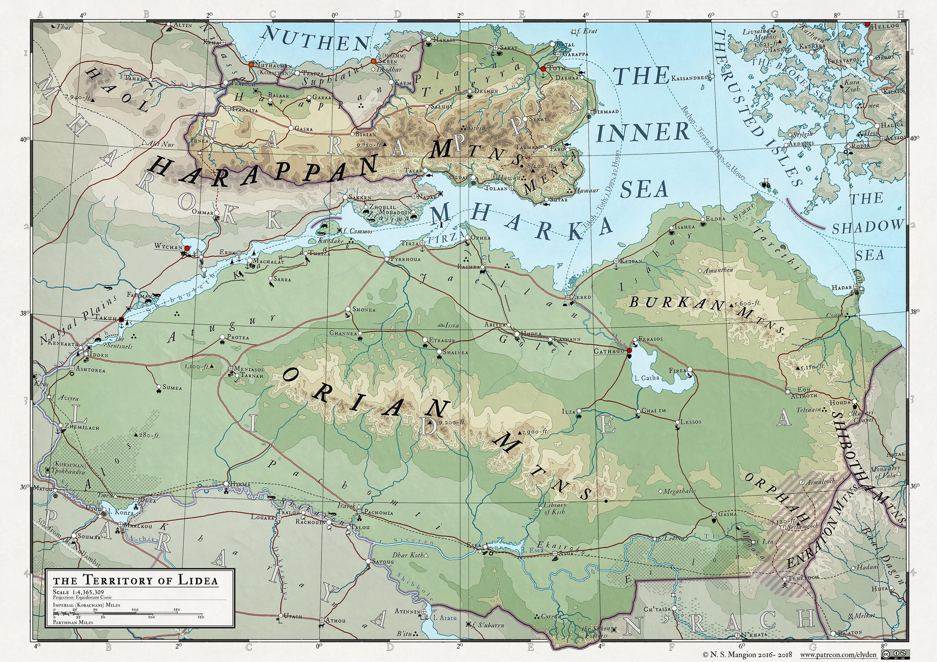
For more on my maps you can check out my Patreon.
This was a quick one to make - most of the topography was already finished, and much of the labelling was done from previous work done on bordering nations, so I just had to do the central area of the map.
The next map will likewise be a quick one, as it details the region to the W of here - Mharokk, which has even more work finished for it from this map and the Vaalk map I had done last year.
A key to the map and others in the series can be found here
LIDEA
Lidea is a relic nation, bearing fragments of earlier nations, such as the Naahi empire and the City state of Conth, both of which were descended from the older and far greater Thym, which dominated northern Sammaea in the Fourth Age. Ruins and abandoned monuments of the Thymi empire can still be seen in the Jaellan plains and Atugur, though they are half-buried and eroded, their names unknown to most. More recent in the collective memories of Lideans are the ruins of the Korachani empire, which, following its sundering in 3705 RM abandoned the region to the reformed empire based in Sarastro, in the east. Most structures were converted by the Sarastroan government, though elsewhere they were left to rot or were torn down.
The region had been under Korachani control since 911 RM, after which lacer territories in the east (then controlling a 200-mile wide corridor between Ba’ath and Lidea) were destroyed. The people of Lidea acheived independence in 1280 RM, following the slaying of the Shaper Sæchin in Artalscelli, though Korachan later regained control in 1421 RM.
The river Shibboleth, one of the longest and most storied rivers in all of Elyden was dammed in Æthios in 2943 RM with the creation of the Alaundel dam, negatively impacting life downstream, including Lidea. Over subsequent years many settlements located along its course died after its flood cycles stopped. This was true of various nations along the course of the Shibboleth and forced the Korachani empire to send troops into Æthios in 3002 RM, finally destroying the dam in 3017 RM. Though by then most of its manufactories had fallen silent, the landscape changed by the appearance of the dam, the patrician and magnate houses that operated them, moving elsewhere.
One aspect of Lidean life I came up with (of all things, when watching a Joanna Lumley documentary about the Nile) was the drinking houses that form a focal point of Lidean communities:
Alcohol consumption is controlled in Lidea, and drinking is restricted to drinking halls - large structures that dominate all Lidean settlements. They are built around a large hall in which people drink and eat the tea and spicy foods the region is renowned for. It is common for Lideans to spend most of their free time in the drinking halls mingling with family and friends . Festivals and holidays are celebrated in the halls as much as they are in temple, and in some settlements the two can be the same structure.
Halls are segregated by sex so individuals can talk about subjects that are taboo with the opposite sex. Fourteen year olds of both sexes undergo a rite of passage with family, who urge them to drink until they get blisteringly drunk. Only after such an embarrassment are they considered to be adults, and can frequent the halls unchaperoned.
Each hall brew its own alcohol, leading to competition and partisanship amongst patrons.
Image size
2894x2046px 5.1 MB
© 2017 - 2024 vorropohaiah
Comments4
Join the community to add your comment. Already a deviant? Log In
Thank you for sharing this! I really love the topographical style. Is that done manually, or is there some filter or process for creating it? I'd love to see a tutorial on this kind of map 😁